

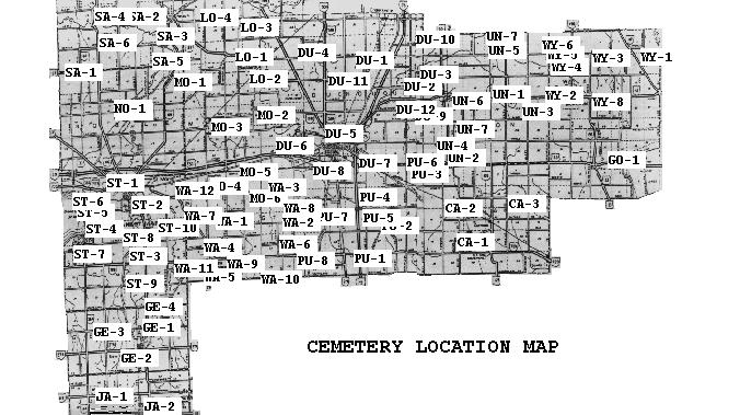
Auglaize County Cemetery Locations
Contributed by Mark Gierhart at The GIERHART Family Inn, to help you locate the many cemeteries throughout Auglaize County, below is a map followed by a location description for each cemetery. The links to cemetery lists & photos are all offsite. You must hit your back button to come back to this Auglaize County site. Please let me know if I have an incorrect link or if you another link to add.
Also Check out:
- Cemeteries from Auglaize county in the USGenWeb's Tombstone Transcription Project ~ Cemetery Transcription Library
- Find A Grave ~ Searchable Database of Cemetery listings, including pictures of headstones.
- Internment.net ~ Searchable Database of Cemetery listings.
- Ohio Gravetone Photo Project ~ "The mission of this project is to capture digital images of gravestones of our ancestors. As decades pass-- many stones are becoming harder, if not impossible, to read the inscriptions they originally contained." Searchable Database
- United States Funeral Home Directory ~ From the National Obituary Archive (NOA)
CLAY TOWNSHIP
CA-1 George Geyer - German Methodist CemeteryWithin city limits of Geyer. Near Cherry Street and DT&I Rairoad.
CA-2 Geyer - Gardner - Kaiser Cemetery
On Geyer Road. 5 miles South of St. Johns, 1 mile East of the village of Geyer.
CA-3 Mt. Tabor Cemetery
On Gutman Road, 1/4 mile East of the village of Gutman.
CA-4 St. Mark's Lutheran Church Cemetery (AKA Geyer, AKA Helmlinger)
Located on Geyer Rd. (207), 5 miles South of St. Johns, OH and 1 mile west of Geyer, OH. Cemetery is off of Geyer Drive (205).
DUCHOUQUET TOWNSHIP
DU-1 Bethel - Union Bethel CemeteryOn County Road 25A between Buckland-Holden Road and Hengster Road.
DU-2 Conner - Gardner - Kaiser Cemetery
1000 feet off Hengster Road and 1500 feet off Town Line Road.
DU-3 Craft - Presar Cemetery
On Town Line Road, 2 miles North of the village of Uniopolis.
DU-4 Crawford - Romshe Cemetery
On St. Rt. 501 at Richie Road, 5 miles North of Wapak.
DU-5 Evergreen Cemetery
On Silver Street at corner of North Water Street by railroad tracks in Wapak.
DU-6 Greenlawn Cemetery
Off Cemetery Street Road on West side of Wapak.
DU-7 St. Josephs (New) Cemetery
On County Road 33A , 2 miles Southeast of Wapak.
DU-8 St. Josephs (Old) Cemetery
On Herb Street in Wapak.
DU-9 Presser - United Bethren in Christ Church Cemetery
On Town Line Road, 1 1/2 miles South and 1 1/2 miles West of the village of Uniopolis.
DU-10 Reinhart Cemetery
500 feet off Town Line Road, between National and Sellers Roads.
DU-11 Stuevely - Two Mile - Wheeler
On Wapak-Cridersville Road, between Wapak-Buckland Roadand Buckland-Holden Roads.
DU-12 Tam Cemetery
On Town Line Road South of St. Rt. 67, North of Blackhoof Creek Road
GERMAN TOWNSHIP
GE-1 German Protestant - Lock Two Cemetery (New)On New Bremen and New Knoxville Road at Quellhorst Road.
GE-2 Memorial Park Cemetery (Old)
West Second Street and Herman Street in the village of New Bremen.
GE-3 Plank Road Cemetery
On St. Rt. 274, 1/2 mile West of New Bremen.
GE-4 Willow Grove Cemetery
On New Knoxville and New Bremen Road, 3 1/2 miles North of New Bremen.
GOSHEN TOWNSHIP
GO-1 Hull Graveyard - Walnut Hill CemeteryOn St. Rt. 385, 1 1/4 miles East of the village of New Hampshire.
JACKSON TOWNSHIP
JA-2Egypt - St. Josephs CemeteryOn St. Rt. 364 at Minster-Egypt Pike Roads, 3 miles West of Minster.
JA-2 Minster - St. Augustine Cemetery
On Minster-Egypt Road in Minster.
LOGAN TOWNSHIP
LO-1 Baker Jacob - Jacob Baker CemeteryOn Kossuth-Buckland Road (St. Rt. 197)Northeast of the village of Buckland.
LO-2 Buckland Cemetery
In the village of Buckland.
LO-3 Ft. Amanda Cemetery
On St. Rt. 198, 3 1/2 miles North of Buckland.
LO-4 German Zion Cemetery
On Eisley Road, between Burnfield Road and Kossuth-Amanda Road. 1 1/2 miles East of Kossuth.
MOULTON TOWNSHIP
MO-1 Bailey - Green Bailey CemeteryOn Rapp Road, 4 miles North and 1 1/2 miles West of the village of Moulton.
MO-2 Crow Cemetery
On Buckland-River Road, 3 miles Southeast of the village of Buckland.
MO-3 Glynwood - St. Patrick - St. Thomas Cemetery
On Glynwood and New Knoxville Road in Glynwood.
MO-4 Green - Luthern Cemetery
South of County Road 33A, between Kettlersville and Bay Roads.
MO-5 Julian - Pusheta Cemetery
On County Road 33A , 1 mile West of Wapak.
MO-6 Zion Cemetery
On Kettlersville Road, 2 miles West and 1/4 mile South of Wapak.
NOBLE TOWNSHIP
NO-1 Johns Cemetery400 feet off St. Marys River Road, 3 miles North of St. Marys.
PUSHETA TOWNSHIP
PU-1 Catholic - Rupert - St. Peter CemeteryOff Kew Knoxville-Santa Fe Road at corner of Cemetery Road.
PU-2 Fryburg - St. Johns Catholic Cemetery
On Fryburg Road in Northeast section of the village of Fryburg.
PU-3 Harruff - St. David Cemetery
On US 33, 2 1/2 miles West of St. Johns,2 miles East of Wapak.
PU-4 Keller - St. Johns Luthern Cemetery
Off Cemetery Road, 1 mile South of US 33.
PU-5 New St. Johns Lutheran - St. Johns Lutheran Cemetery
On Pusheta Road at the corner of Cemetery Road.
PU-6 Old St. Johns Luthern Cemetery
On Pusheta Road, West of Wapak-Freyburg Road.
PU-7 Schemmel Cemetery
On County Road 25A, 4 miles South of Wapak.
PU-8 Scott - Shanahan Cemetery
Intersection of St. Rt. 219 and Hardin Pike Road.
ST. MARYS TOWNSHIP
ST-1 Benner Cemetery
On Defiance Street in St. Marys.
ST-2 Catholic - Gethsemane - Old Catholic Cemetery
On Plum Street and Lane Street near Canal Street in St. Marys.
ST-3 Dowty Cemetery
300 feet off St. Rt. 66, 2 miles South of St. Marys.
ST-4 Elm Grove Cemetery
On Greenville Road, at Southern edge of St. Marys.
ST-5 Elm View Cemetery
On Greenville Road. Now incorporated with Elm Grove Cemetery.
ST-6 Evangelical Lutheran Cemetery
On Main Street in St. Marys.
ST-7 Evergreen Cemetery
On Greenville Road. Now incorporated with Elm Grove Cemetery.
ST-8 Gethsemane Cemetery
Lake Ave, Web Street and Granville Road in St. Marys.
ST-9 Koop Cemetery
On County Road 66A, 1/8 mile South of Koop Road.
ST-10 Murray - Nott Cemetery
In Southeast part of St. Marys.
SALEM TOWNSHIP
SA-1 Calvary Methodist CemeteryIntersection of St. Rt. 197 and Maier Barber Road.
SA-2 Deep Cut - Mt. Union Cemetery
Corner of Briggs and Deep Cut Roads, 3 miles South of the village of Kossuth.
SA-3 Kossuth Cemetery
On St. Rt. 197 in Kossuth.
SA-4 New Salem Cemetery
On St. Rt. 116 at Deepcut Road, 5 miles Northwest of Kossuth.
SA-5 Pratt Cemetery
On St. Rt. 66, 1 1/2 miles South of Kossuth.
SA-6 Robbin Cemetery
On St. Rt. 116 and Baker-Wright Roads 8 miles North of St. Marys.
UNION TOWNSHIP
UN-1 Fairmont CemeteryOn Fairmont Road, 3 1/2 miles West of Waynesfield.
UN-2 Lockhart Cemetery
On St. Rt. 65 , 3 1/2 miles North of St. Johns.
UN-3 Mt. Lookout - Rinehart Cemetery
Off St. Rt. 67 , 2 3/4 miles West of Waynesfield.
UN-4 St. Johns Cemetery
On St. Rt. 65 in the village of St. Johns.
UN-5 Stiles Cemetery
1000 feet off Wrestle Creek Road, 800 feet off Allen County Line Road.
UN-6 Vaughn Cemetery
On Fairmont Road, 1 mile North and 3 miles East of Uniopolis.
UN-7 Wesley Chapel Cemetery
On Wrestle Creek Road South of Blank Pike Road.
WASHINGTON TOWNSHIP
WA-1 Arnett CemeteryOn Cook-Moulton New Knoxville Road between Washington Pike and Cloverleaf, 2 miles Southof Moulton.
WA-2 Burke Cemetery
On Kohler Road, between Owl Creek and Burr Oak Roads.
WA-3 Dietz Cemetery
Off Kettlersville Road between Washington Pike and County Road 33A.
WA-4 Evangelical Protestant Cemetery
On St. Rt. 29 between Southland Road and the village of New Knoxville.
WA-5 First German Reformed Cemetery
On South Street in the village of New Knoxville.
WA-6 Hittpole - Roberts Cemetery
On Kohler Road between Headapohl and Burr Oak Roads.
WA-7 Hudson Cemetery
1000 feet off East Shelby Road, between St. Rt. 29 and Schultz Road.
WA-8 Kuntz - Wiseley Cemetery
On Kohler Road between Owl Creek and Burr Oak Roads.
WA-9 Methodist Cemetery
On German Street in New Knoxville.
WA-10 Olive Branch - Shinebone Cemetery
On St. Rt. 219 between Knierim and Kohler Roads.
WA-11 Pilger Ruhe Cemetery
On New Bremen-New Knoxville Road, 1 mile West of New Knoxville.
WA-12 Resthaven Memory Gardens Cemetery
On County Road 33A, between Townline-Kossuthand Glynwood-New Knoxville Roads.
WAYNE TOWNSHIP
WY-1 Berry CemeteryOff a lane at Gossard E Road.
WY-2 Concord - Payne Cemetery
Off Santa Fe Road, North of St. Rt. 67.
WY-3 Hopewell Cemetery
On St. Rt. 117 at the Hopewell Church2 1/2 miles Northwest of the village of Holden.
WY-4 Horn Cemetery
On St. Rt. 196, 2 3/4 miles North of Waynesfield.
WY-5 Mars Hill - Morris Hill Cemetery
At St. Rt. 196 and Buckland-Holden Road.
WY-6 Stocker Cemetery
On St. Rt. 196, 1/2 mile North of Waynesfield.
WY-7 Turner Cemetery
On Gossard N Road, 2 1/2 miles South of West Newton.
WY-8 Willow Branch Cemetery
Intersection of St. Rt. 67 and Moyer Road 1 mile East of Waynesfield.
Last Modified & links checked May 30, 2018 8:48:13 PM.